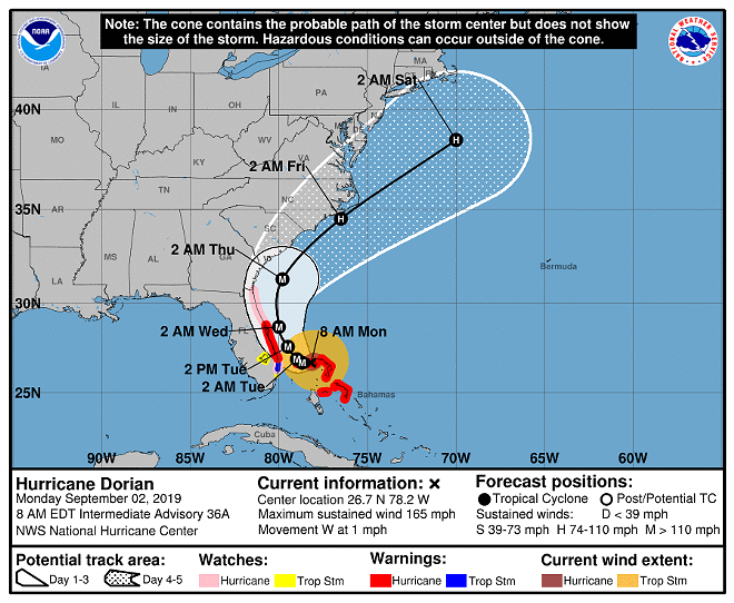
Hurricane Dorian continues to inch westward toward Florida, ravaging the Bahamas, as its movement and winds slowed only slightly overnight.
With sustained winds of 165 mpg and gusts measured at 220 mph, the hurricane remains a Category 5 monster storm, the strongest measured anywhere on Earth this year.
According to the National Hurricane Center, on Sunday, the storm had grown to 185 mph sustained winds with 220 mph gusts, before making three landfalls in the Bahamas.
On this track, the core of extremely dangerous Hurricane Dorian will continue to pound Grand Bahama Island through much of today and tonight," said the NHC in the Monday 8 a.m. advisory. "The hurricane will move dangerously close to the Florida east coast tonight through Wednesday evening."
It is already responsible for at least one death, with several people missing, according to accounts from the islands on social media and in the Bahamas Press.
One particularly chilling video filmed by a mother in Abaco Islands and shared by a Bahamian events promoter shows the destruction and danger of the flooding there.
A desperate cry for help 😢😢😢😢#HurricaneDorian #Abaco #Bahamas Lord please help us pic.twitter.com/874BEsiB8t
— MVP (@mvp242) September 1, 2019
The Guardian is reporting at least 13,000 homes destroyed or severely damaged. CNN Grand Bahama Airport is under 5 feet of water. Another video from the same account shows cars and homes completely submerged.
While forecasts over the past several days have expected Dorian to begin moving north and later east, drenching the coasts of Florida, Georgia, and South Carolina, the storm's current 1 mph crawl westward across the Bahamas has inland Central Floridians considering the effects of a direct hit.
"Although gradual weakening is forecast, Dorian is expected to remain a powerful hurricane during the next couple of days," said the NHC in the advisory.
Orange County can expect winds 35-45 mph with 2 to 3 inches of rainfall, enough to bring down trees and cut power. If Dorian does not take the expected northern route, the effects could worsen. Orlando remains in the "cone of uncertainty" for the eye's path.
Brevard County emergency officials are now calling for evacuations to begin at 8 a.m. Monday, for people order for people living in the barrier islands, low-lying and flood-prone areas, mobile homes, and people with disabilities.
Volusia County will begin mandatory evacuations for certain areas at 10 a.m. on Monday. Residents on the beachside, in low-lying areas, and in RVs and mobile homes throughout Volusia should plan to relocate.
Flagler County has ordered the evacuation of nursing homes, assisted living facilities, and group homes within three coastal zones, starting 8 a.m. on Monday. Hurricane Wilma, by comparison to Dorian, was considered the most intense tropical Atlantic cyclone ever recorded, reaching wind speeds of 185 mph in 2005.
On Sunday, tolls were suspended on Florida’s Turnpike and other roads in South Florida and Central Florida
We will continue monitoring the storm throughout Monday.
Follow @cl_tampabay on Twitter to get the most up-to-date news + views. Subscribe to our newsletter, too.


