
Here's our hurricane update, distilled down so you don't have to freak out:
As of the 12 p.m. Atlantic Standard Time update from NOAA's National Hurricane Center,
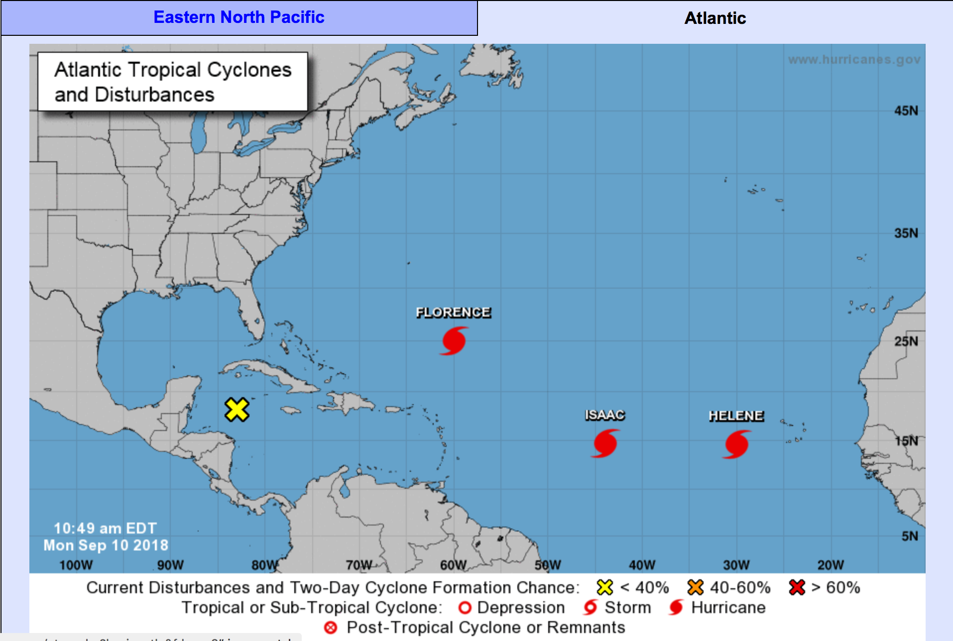
Hurricane Florence has grown into a Category 4 hurricane with maximum sustained winds of 130 MPH. The storm's central pressure's at 946 millibars (down from 962 at the 11 a.m. AST update) and it's moving west at 13 MPH. Forecasters at the National Hurricane Center keep telling us the storm's going to start heading north soon, and if it does, it's going to be trouble for the Carolinas. If it does't, east Florida may be screwed.
The worst it could mean for Tampa Bay: We might get wet.
Should we panic? No.
What should we do? If you have friends who live in the Carolinas, maybe offer them a place to stay. Or not. After all, it is Florida in September and we don't have the best hurricane track record.
Hurricane Helene is taking her sweet-ass time over there off the coast of Mauritania, growing into a Category 2 hurricane with maximum sustained winds of 105 MPH. This storm's central pressure is 974 millibars. Hurricane Helene's currently making its way west at 16 MPH, but NHC forecasters say they're pretty sure Hurricane Helene will turn north, too — although this hasn't happened yet. If it does, the predicted track spells trouble for... um, Greenland? If it doesn't, well, it's really anyone's guess as to who's screwed.
The worst it could mean for Tampa Bay: If Hurricane Helene doesn't turn north — and that's a big if, y'all — we might get a direct hit, but not until after this storm makes life hell for every island south of us — and perhaps South Florida.
Should we panic? No.
What should we do? Well, you know, we'd like to say "nothing" but we do believe in not tempting fate, so if you wanted to go ahead and maybe buy a few extra gallons of water and beer, hell, it can't hurt.
Hurricane Isaac — we're not going to sugar-coat this — has us concerned. Now, we're journalists, not hurricane forecasters, but there are few things of concern here. First, the good better news: Isaac's "only" a Category 1, with maximum sustained winds of 75 MPH, and the central pressure isn't that low yet: 993 millibars. Now, the stuff we aren't loving: Hurricane Isaac's a slowpoke, meandering along at a slower clip — 14 MPH, and, like Helene, it's a low storm. Unlike Helene, NHC forecasters don't expect Isaac to turn north. That puts every island between us and Mexico pretty much in its path. It should weaken over land, which sucks for the islands and really doesn't help us much, because once the storm makes it offshore, it's likely to strengthen again.
The worst it could mean for Tampa Bay: Hurricane Helene "catches" Hurricane Isaac and they join forces, leaving a swath of destruction that could decimate the islands, flood coastal Tampa Bay and bring severe hurricane winds to Florida.
Of course, that's a severe dramatization. What's more likely? Isaac will do some damage to the islands, weaken, re-strengthen and make its way into the Gulf. Where it goes from there? Anyone's guess right now.
Should we panic? No. At least, not yet.
What should we do? All we can do is hope this slowpoke of a storm picks up speed, because that'll keep it relatively small, and get your water and batteries now. Also, fill your gas tank and maybe make plans this weekend to trim that big oak tree hanging over your bedroom roof.
Disturbance #1 is a that tiny yellow x you see off the coast of Mexico in the northern Caribbean sea. It's sort of the runt of the litter, and NHC tells us right now it has a 10% chance of turning into a hurricane. Of course, last night, this little guy had a 0% chance, so never say never. Fun fact: Although not as common as storms forming in the Atlantic or eastern Caribbean, Hurricane Camille (1969, Category 5, 256 deaths), Hurricane Agnes (1972, Category 1, 122 deaths), Hurricane Opal (1995, Category 4, 9 deaths), and Hurricane Keith (2000, Category 4, 24 dead) all formed right about where Disturbance #1 is right now.
The worst it could mean for Tampa Bay: Total destruction, but it's too soon to tell.
Should we panic? Look, right now, all we have is a bunch of rain and thunderstorms. You should be more concerned that you'll crash your car going to get hurricane provisions than whether or not this storm's going to hit us.
What should we do? As with all storms, while it's fun — for some — to read coverage here (and watch it on TV, and place bets on where The Weather Channel will send Jim Cantore), the smartest thing you can do is turn off your TV and get your information from the National Hurricane Center. As we've said before, that's the most reliable information out there, and also — this is important — the only source of information not beholden to how many clicks/ market share points they get, so there's less of an incentive to scare you.
WTF does pressure and movement have to do with a storm?
Lower pressure = more severe storm
Faster forward movement = smaller storm
Faster winds = more power lines down, more shouty people on the phone with TECO and Duke
