
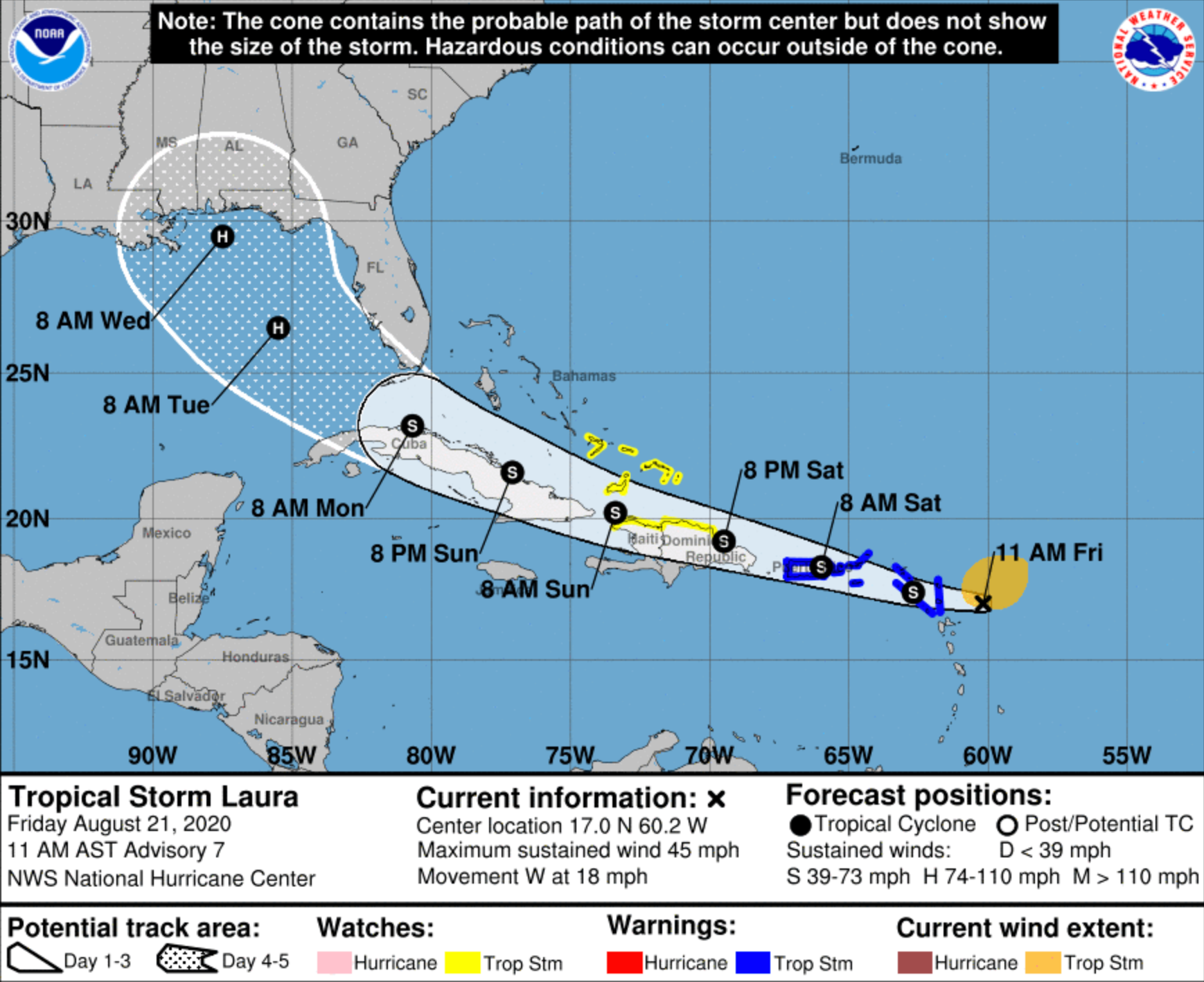
Forecasters with the National Hurricane Center say Tropical Storm Laura formed Friday morning, and is projected to impact Florida early next week as a major hurricane.
According to the 9 a.m. advisory, Laura is quickly making its way west near the Caribbean at about 21 mph. The storm is about 230 miles east-southeast of the northern Leeward Islands and currently has sustained winds of 45 mph.
It’s still too early to determine its exact path and strength over the next few days, but Laura is projected to hit the Florida Keys on Monday, and move over a portion of the Gulf of Mexico where it should be generally favorable for development, says the NHC.
“The upper-level winds over the Gulf of Mexico should be generally favorable for development if the cyclone doesn't get too close to Tropical Depression Fourteen,” says the advisory. “The possibilities range from the system degenerating to an open wave as seen in the GFS and ECMWF to a major hurricane as seen in the HWRF.”
As of now, the Tampa Bay region is still in the cone of uncertainty, and is expected to be impacted by Laura on Tuesday, says models from the NHC.
9:05 AM EDT: NOAA Hurricane Hunter aircraft finds that TD 13 has strengthened to Tropical Storm #Laurahttps://t.co/meGFS0Han4 pic.twitter.com/m85ApKXFeE
— National Hurricane Center (@NHC_Atlantic) August 21, 2020
There is currently a tropical storm watch for the southeastern Bahamas, including the Acklins, Crooked Island, Long Cay, the Inaguas, Mayaguana, and the Ragged Islands, as well as for the Turks and Caicos Islands, St. Maarten, Saba, St. Eustatius, Antigua, Barbuda, St. Kitts, Nevis, Anguilla, St. Martin and St. Barthelemy. Also, Puerto Rico and the U.S. Virgin Islands are under a tropical storm watch.
Meanwhile, Tropical Depression 14 is still looming 160 miles east of Isla Roatan Honduras, moving at about 12 mph towards theHonduras coastline. This storm has maximum sustained winds of 35 mph.
TD 14 is expected to develop into a tropical storm by Friday evening, and at the point it will become Tropical Storm Marco.
The storm is expected to move over the Yucatan Peninsula late Saturday, and then into the warm waters of the Gulf, where forecasters say it is likely to strengthen into a hurricane by early Monday morning as it approaches the Texas coast line.
Support local journalism in these crazy days. Our small but mighty team is working tirelessly to bring you up to the minute news on how Coronavirus is affecting Tampa and surrounding areas. Please consider making a one time or monthly donation to help support our staff. Every little bit helps.
Subscribe to our newsletter and follow @cl_tampabay on Twitter.
